The Cordilleran ice sheet deposited many fossils throughout the Pacific Northwest. Radio carbon dating provides evidence of four glaciations, the most recent being the Fraser (which correlated with the Wisconsin Glaciation). Earlier glaciations were known as the Salmon Springs, Stuck and Ortung. Ice sheets advanced south into the lowlands of western Washington at least 6 times.
Between glaciations were periods of warming when the Olympia beds in western Washington accepted fossil impressions in peat, tephra, lahars, mudflows, lacustrine and fluvial deposits. Many of the these Olympia beds yield excellent pollen preservation (pine and spruce), freshwater diatomite suggesting clear shallow lakes and larger fossils including mammoth teeth and tusks, cones, needles, branches, leaf prints and tree roots. Mastodons, mammoths and bison roamed the Puget and Fraser lowlands during this nonglacial interval.
In the Central Puget Lowland glacial lakes formed south of the retreating ice front, coalescing into one lake, Lake Bretz. Sea level change has also been a significant factor in the fossil record, with a range of 200 meters above present level to 100 meters below as a result of eustasy (change in water volume), isostasy (growth and decay of ice sheets) and tectonism (plate slippage and faults). I'd like explore this relationship as a metaphoric expression in flume particularly as it relates to mechanically-cut surface and alignments of the stonework...perhaps as a sort of regional map that could only be deciphered aerially (by drone?).
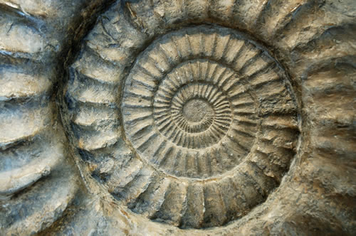
The glacial lakes of the Pleistocene left a larger carved terrain and a range of smaller fossil deposits. Typical among them are as follows...


Between glaciations were periods of warming when the Olympia beds in western Washington accepted fossil impressions in peat, tephra, lahars, mudflows, lacustrine and fluvial deposits. Many of the these Olympia beds yield excellent pollen preservation (pine and spruce), freshwater diatomite suggesting clear shallow lakes and larger fossils including mammoth teeth and tusks, cones, needles, branches, leaf prints and tree roots. Mastodons, mammoths and bison roamed the Puget and Fraser lowlands during this nonglacial interval.
In the Central Puget Lowland glacial lakes formed south of the retreating ice front, coalescing into one lake, Lake Bretz. Sea level change has also been a significant factor in the fossil record, with a range of 200 meters above present level to 100 meters below as a result of eustasy (change in water volume), isostasy (growth and decay of ice sheets) and tectonism (plate slippage and faults). I'd like explore this relationship as a metaphoric expression in flume particularly as it relates to mechanically-cut surface and alignments of the stonework...perhaps as a sort of regional map that could only be deciphered aerially (by drone?).
The glacial lakes of the Pleistocene left a larger carved terrain and a range of smaller fossil deposits. Typical among them are as follows...


No comments:
Post a Comment